![]()
![]()
![]()
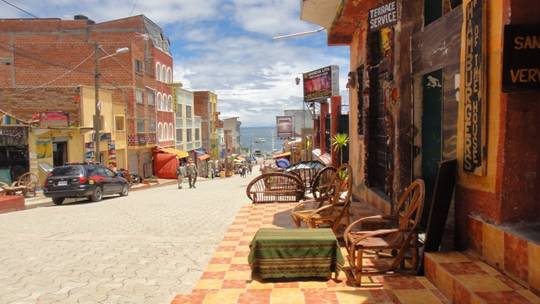
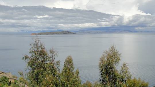
Several hours later, we reach Copacabana, a small tourist town on the shores of Lake Titicaca. The lake is 12,500 feet above sea level and Mike has booked us into a convenient hotel, only two blocks off the main street. Unfortunately for us, the booking website neglected to mention that it is two blocks up an incredibly steep street. Our bus is late arriving in Copacabana and the boat tours are leaving shortly. The day is cloudy and cool and, in our hurry, we forget our hats and neglect to put on sunscreen. By the time we think of it, neither of us is keen to make another labourious, high-altitude climb to the hotel. We should have made the effort! As soon as the boat sets out, the clouds disappear and I get another vicious sunburn, maybe even a mild sunstroke. Even Mike, who hasn’t had a sunburn in twenty years, is also suffering by the end of the day.
|
|
|
|
Slow climb up to our hotel |
Copacabana main street |
|
|
|
|
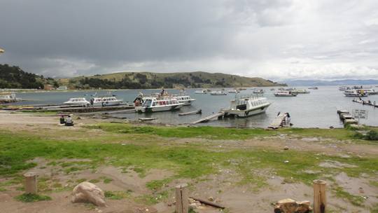
Tour boats to visit the Isla del Sol |
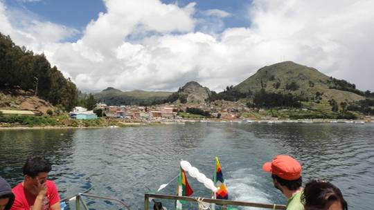
Looking back at Copacabana |
|
|
|
|
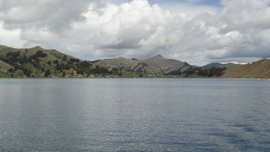
Beautiful Lake Titicaca |
Island of the Moon |
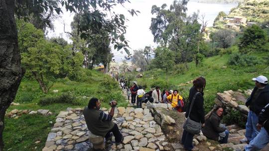
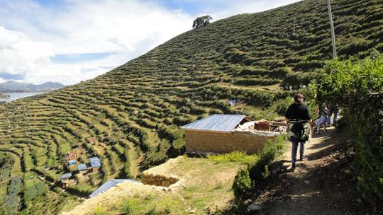
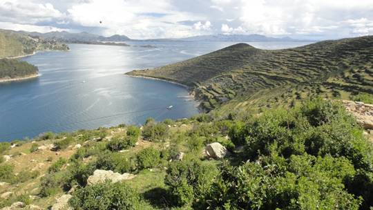
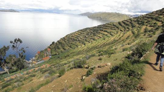
The tour boat takes us two hours across Lake Titicaca to the Island of the Sun (Isla del Sol), where the Inca believed their Sun God was born. We disembark at the village of Yumani and our guide leads us on a hike across the island. The Incas were tremendous builders of terraces on steep mountainsides. These terraces, many of which are still in use today, increased the amount of land for cultivation and helped prevent erosion. Our hike leads us straight up over terrace after terrace. We stop frequently to puff and pant like steam engines and let our heart rates get back to normal. Four or five hundred feet above the lake, our guide heads off along one of the terraces, to our immense relief. The view down to the village and tiny harbour below is awesome and the terraces themselves are incredible works of engineering, built by a society who had no draft animals and did not use the wheel. Many of the terraces are just used for grazing, but some grow corn, potatoes, wheat and other crops which we can’t put a name to. One very common crop is lupines, which are a staple food source. Our excellent guide, a young Aymara, speaks so slowly and clearly that neither of us have any difficulty understanding nearly all of his Spanish. After nearly an hour, our path descends to lake level where our tour boat is waiting to take us back to Copacabana.
|
|
|
|
Climbing the terraces – very slowly! |
Hiking horizontally, finally! |
|
|
|
|
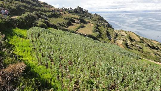
Views of the Isla del Sol |
|
We see many patches of plants that grow two or three feet tall with oval,
grayish-green leaves. I finally ask someone what they are. He looks at me as
if everyone would recognize coca plants! Almost every little farm has a field
of coca right next to the potato patch. Everybody here drinks maté or
coca leaf tea and many people chew coca leaves to alleviate altitude sickness.
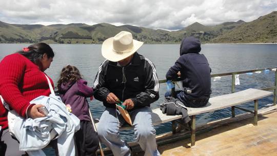
A fellow on our boat pulls out a leather pouch and stuffs a wad of coca leaves
in his cheek. Then he opens a tiny jar containing lime, wets his finger and
puts a dab in his mouth. Apparently, the lime releases the alkaloids in the
leaves. By the time we reach the top of the terraces, we wish he would offer us
a handful.
|
|
|
|
Patch of coca plants |
Some coca leaves for chewing |
Between the long day, the altitude sickness and a touch of sunstroke, we are barely able to finish the excellent bottle of Chilean cabernet sauvignon for supper. By the time we are ready to tackle the final ascent to our hotel, it is pouring rain and the electricity is off. Even though insomnia is a typical symptom during acclimation to high altitude, neither of us has any trouble sleeping this night.
February 24
The bus for Puno doesn’t leave until 1:30, so we have good lie-in and recover
our strength. We lounge around town, drinking coffee and enjoying the sunshine
and the leisure time. Twenty minutes after getting on the bus, it stops at the
border. We all troop into the Bolivian border post to clear out of the
country. Each country gives you a ticket with an immigration stamp when you
enter and you have to get it stamped again on leaving. God help you if you lose
that ticket! Then we all hike a couple of hundred meters down the road to
Peruvian migracion, where we line up again to enter Peru. Then it is
back on the bus and down the road to Puno.
There isn’t much to do in Puno, so Mike and I, as if the altitude sickness isn’t enough, manage to do ourselves a great deal of further harm. Cusceña beer comes in several 620 ml bottles, we meet some British people and then they join us for dinner. Over the course of the evening, along with a lot of conversation, we do away with several bottles of Chilean wine.
February 25
Up at 5:30 am to get to the bus station. This altitude sickness thing is really
brutal -- headache, nausea, dizziness, muscle tremors – in fact it feels a lot like a hangover....hey, wait a minute....do you suppose? Maybe some coca
leaves would help?
The 400 Km bus trip from Puno to Cusco is really neat, because it is more like a tour. We have an excellent guide, who does a bilingual commentary, explaining things we see and teaching us a great deal about the Incan civilization. Two stewardesses serve cold drinks and cups of maté. We stop at several places of interest along the way, where our guide takes us around, explains their significance and points out interesting features.
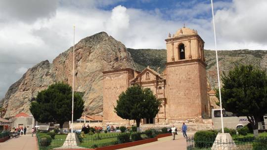
Our first stop, about an hour out of Puno, is at Pukará. A very interesting museum showcases artefacts from a pre-Incan culture that dates back to 1600 BC. The village has an interesting church. In protest against the brutality of the Spanish Conquistadores, the local people refused to finish the second tower.
|
|
|
|
Church in Pukará with unfinished tower |
Little bull figures on the gate posts are symbols of strength and fertility |
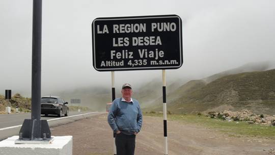
The eastern and western cordilleras have been drawing closer to us and they finally merge into the Knot of the Andes at La Raya pass. The bus stops briefly to let us off, so we can try breathing at 14,305 feet. Our guide explains that the pass represents, not only the dividing line between Puno and Cusco regions, but also separates the Aymara people that we have been seeing since Bolivia and the Quechua people who live in the Cusco valley. Our guide, who is Quechua, also explains that referring to the people as Inca is incorrect. Only the rulers were called Incas.
|
|
|
|
Pass at 14,305 feet between the Puno altiplano and the Cusco Valley |
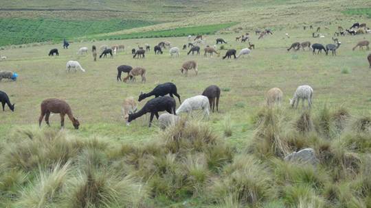
Llamas and alpacas |
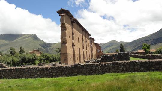
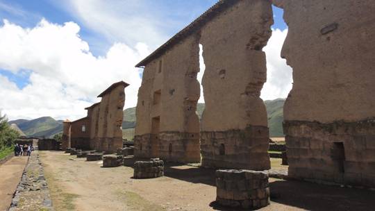
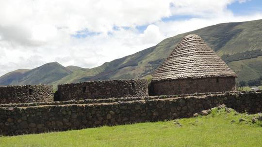
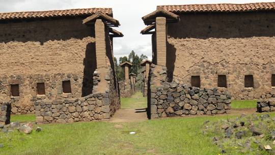
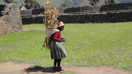
Next stop is at the archaeological site of Raqchi. http://en.wikipedia.org/wiki/Raqchi This was a very important religious site in the Inca culture. The central feature is the enormous Temple of Wiracocha. Much of the original, 60 foot high-central wall, still stands. It is flanked on each side by a row of eleven columns. Prior to its destruction by the Spaniards, the temple had what is believed to be the largest single roof in the Incan Empire, measuring 302 feet long by 84 feet wide. Its peak was supported by the central wall and then it stretched out over the columns on each side. Near the temple are the remains of extensive buildings that were used as storehouses and living quarters.
|
|
|
|
Central wall, Temple of Wiracocha |
Bases of supporting columns |
|
|
|
|
Granaries for storing food |
Reconstructed dwellings |
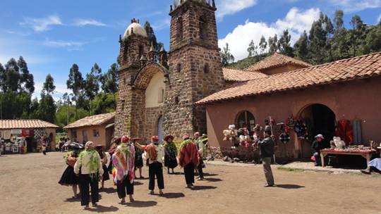
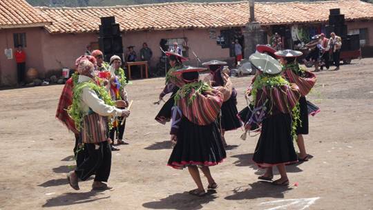
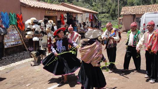
In Raqchi, we also have the opportunity to watch local people, dressed in traditional costumes, performing Carneval dancing. Apparently, carnival actually lasts for three weeks, well beyond Ash Wednesday.
|
|
|
|
Traditional Carneval celebrations in Raqchi |
|
|
|
|
|
Dancing in the village square |
Carrying a burden and spinning at the same time |
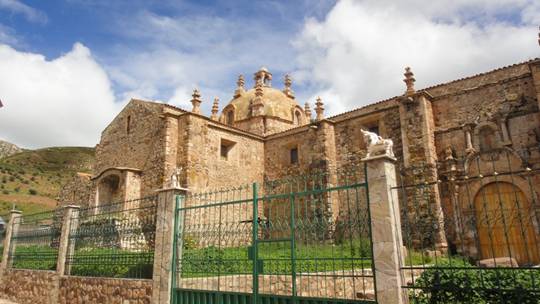
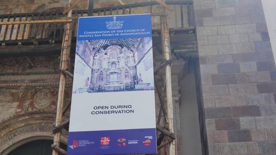
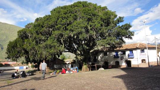
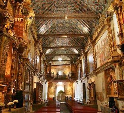
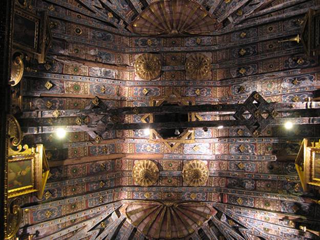
Our final stop is in a small town to visit the amazing San Pedro Apostol de Andahuaylillas Church, built by the Jesuits between 1570 and 1606 on the foundations of an Incan temple. It is called the Sistine Chapel of the Andes, http://www.smithsonianmag.com/travel/The-Sistine-Chapel-of-the-Andes.html and for good reason. The outside is unremarkable but the interior is staggering! The walls bear huge murals, the ceiling is totally decorated with frescoes and the immense altar is completely layered with 22 and 24 carat gold leaf. In the organ loft are two antique pipe organs, dating from the 17th century and even they are covered with elaborate religious artwork. The murals and paintings cleverly merge Christian biblical symbols with Incan traditions, in an effort to attract the Quechua people to the church of the Conquerors. The World Monument Fund and the Spanish petroleum company, Repsol, are carrying out a massive preservation and restoration project.
|
|
|
|
No photos permitted inside the church |
Huge 400-year-old pisonay tree in front of the church |
|
|
|
|
Interior of church (not my pictures) |
Painted ceiling |
By the time we reach Cusco, our ‘altitude sickness’ symptoms have abated considerably (the elevation here is only 11,200 feet). Our boutique hotel is right on the Plaza de Armas. We find a nice restaurant and have a delicious pizza and some fine vino tinto.
![]()
![]()
![]()